Laya Gasa Trek
Overview
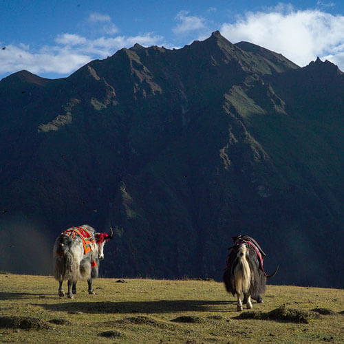
Laya-Gasa Trek, 200km journey takes you through gorgeous alpine meadows, high mountain passes and dense sub-tropical jungles before ending in Gasa. The first half of this trek follow the same route as the Jumolhari Trek through Jigme Singye National Park and offer awe-inspiring views of Mt. Jumolhari, Jichu Drake and Tsherimgang. Along the trail you’ll be able to spot indigenous animals such as blue sheep and Takins, the national animal of Bhutan. You’ll travel through remote mountain villages inhabited by Layaps, a distinct segment of the Bhutanese society with unique culture, traditions and appearance. At the end of the trek at Gasa, you can soak in Hot Spring that is sure to rejuvenate you.
16 Days/15 nights
From US $4270/person

Duration
16 Days

Group Size
2 & above

Trek grade
Hard

Accommodation
Hotels/Camping

Avg. Walking Dist.
17 Km

Best season
Mar-May
Sep-Nov

Avg. Walking Time
6-7 Hours

Max. Elevation
5000m
Tour highlights
- Enjoy the beauty of the snowcapped Jumolhari mountain on your trek.
- Panoramic views of other mountains like Gangchhenta, Kang Bum, etc.
- Trekking to the high pass of Nylie La at 4,830m, Yeli La at 4,820m, etc.
- Opportunity to soak in the healing Gasa Tshachu Hot spring.
- See beautiful Laya Village and its people.
- Hike to Tiger's Nest Monastery prior to your trek.
Itinerary
Upon arrival in Paro, you will be greeted by our representative and transferred to your hotel. After lunch, you will visit the Rimpung Dzong, dating back to the 17th century. This building is an ancient fortress and center of civil and religious government in the Paro valley. From the Dzong, you can walk down to the road head crossing a traditional wooden bridge. From here, you will be taken to Kichu Lhakhang, one of the oldest and the most sacred shrine in the country. In the evening, you can stroll in Paro town. Overnight hotel in Paro.
5Km | 4-5 hours | 900m Ascent
After breakfast, hike to Taktsang (Tiger’s Nest) Monastery, Bhutan’s most famous monastery, which stands at 3180m gives you acclimatization for the next day’s trek. According to the legend, it is believed that Guru Rimpoche, the 8th century Spiritual Master, flew to this location on the back of a tigress to meditate. Explore the Monastery and hike back to Paro. On the way, visit Kyichu Lhakhang, one of the oldest temples in Bhutan.
17Km | 5-6 hours | 300 Ascent | Camp altitude 2850m
The trek starts from the ruins of Drugyal Dzong at 2300m with a downhill walk on a wide trail. The trail climbs gently traversing through well-maintained rice terraces and fields of millet. The route later enters an area of apple orchards and forests. Soon the valley widens and you reach Gunitsawa village where you pass the army post. The campsite is on the opposite side of the river, not far from Gunitsawa. Camp at an altitude of 2850m.
21Km | 6-7 hours | 900 Ascent | Camp altitude 3750m
On this long day, the trail continues with lots of small ups and downs. After going uphill through the river valley the valley finally narrows gradually to a mere path, which descends to a meadow where a camp will be set up at the altitude of 3750m. From here, if weather permits, you will have the first great view of Mt. Jumolhari.
19Km | 4-5 hours | 300 Ascent | Camp altitude 4050m
This morning the trek continues up the Paro Chhu valley, which widens into patches of alpine meadow and scanty growths of forest. You will cross an army checkpoint along the way and enjoy a spectacular view of high mountain ridges and snow-capped peaks. In this area, yaks and their herder’s homes become a regular feature of the landscape. Passing the villages Sio, Takethang and Dangochang is another asset on this day. After reaching Jangothang, one of the most beautiful campsites of the Himalayas, you will again have a spectacular view of Mount Jumolhari and Jichu Drake.
The rest day in Jangothang provides plenty of possibilities for day hikes with great views of lakes and snow capped mountains such as Jumolhari and Jichu Drake. There are good chances to spot some blue sheep on the upper slopes of the valley. Jangothang is a perfect environment for your acclimatization. You can also trek up to Tsophu Lake or hike around the area.
19Km | 6-7 hours | 800 Ascent | 730 Descent | Camp altitude 4100m
The trail follows the stream or half an hour and crosses the bridge to the right side. Start the climb up to the first ridge with a breathtaking view of Jumolhari, Jichu Drake and Tshering Gang. Then walk towards the valley, almost flat for a while, until the climb to the Ngye La pass at an altitude of 4830m. After the pass, it is a gradual descent to the Lingshi camp, enjoying the panoramic view of the peaks and Lingshi Dzong.
12Km | 5-6 hours | 100m Ascent | 250m Descent | Camp altitude 3850m
Shortly after starting you will reach a Chorten below Lingshi Dzong. Here, you have the choice of staying on the main trail or taking a detour up to the Lingshi Dzong (4220m), which sits right atop a high ridge. After Lingshi Dzong, It is an easy day and pleasant walk through villages and yak herders camp. On reaching the campsite at Chebisa, you will have plenty of time to visit the village houses. There is also a beautiful waterfall located behind the village that is worth visiting.
17Km | 6-7 hours | 570m Ascent | 290 Descent | Camp altitude 4130m
The morning starts with a long ascent behind Chebisa Village through a wide pastureland towards Gobu La pass at an altitude of 4420m. On the way, you will see a few people herding yaks and you may also see herds of blue sheep now and then. After crossing Gobu La, you descend into the valley, then climb again a little bit, before descending again to Shakshepasa (3980m), a large U-shaped valley. Climbing from here you will finally reach the campsite at Shomuthang, above a river, which is a tributary of the Nochu river.
15Km | 5-6 hours | 620m Ascent | 590 Descent | Camp altitude 4160m
You begin by climbing up the valley. Edelweiss abounds along the trail. The snow peak you can see to the southeast is Kang Bum (6526m). After two hours of climbing you will reach Jhari La (4750m), from where you catch the first glimpse of Sinche La, the pass you will have to cross the day after. The big snow peak in the north is Gangchhenta 6840m, better known as the Great Tiger Mountain. The camp by the river is called Tsheri Jathang located in a beautiful wide and remote valley. Climb up a little bit and you will reach the campsite at Robluthang in a rocky meadow.
19Km | 7-8 hours | 850m Ascent | 870m Descent | Camp altitude 4140m
It is a long climb unto Shingela pass (5010m). The view of the mountains from the path is stunning. As you descend, you will see an impressive terminal moraine and a glacial lake at the foot of the valley. Below the moraine, you cross the Kango Chhu and soon reach the Lingmithang campsite. The peak of Gangchhenta towers over the campsite even though it’s quite a distance away.
10Km | 3-4 hours | 60m Ascent | 340 Descent | Camp altitude 3850m
In the morning you wake up with a superb view of Gangchhenta peak in front of you. The walk to Laya is very pleasant with wonderful views. You will pass through a damp forest, filled with moss and singing birds. Arrive at Laya village, the second highest settlement in the country, at altitude of 3850m. From the west of the village, you will have spectacular views of Mt. Gangchhenta and catch Mt. Masagang.
19Km | 6-7 hours | 50 Descent | Camp altitude 3800m
Descend to army camp and join the Mo Chhu river. Follow the river till you cross the bridge. After the bridge it is up and down several times, through juniper and fir forests until you reach Koena at an altitude of 3,800m. You will be met by your car and drive to Gasa through fir, spruce and rhododendron forests. You soak in Gasa Hot Spring, which has curative values for various ailments.
Today you will drive to Punakha on unpaved roads. The drive is through the high agricultural benches above the Mochu (Chu means River) into a lush semi-tropical gorge filled with banana trees and creepers. After lunch, you will visit the Punakha Dzong, which is one of the most beautiful Dzongs in Bhutan. Overnight hotel in Punakha.
Set out for Thimphu with a stop at Dochu La Pass for tea, where on a clear day you can get spectacular views of the Himalayas. Check into your hotel on arrival in Thimphu. In the afternoon, you can stroll freely in Thimphu city. Overnight hotel in Thimphu.
In the morning, you will drive to the airport for departure. Our representative will bid you farewell.
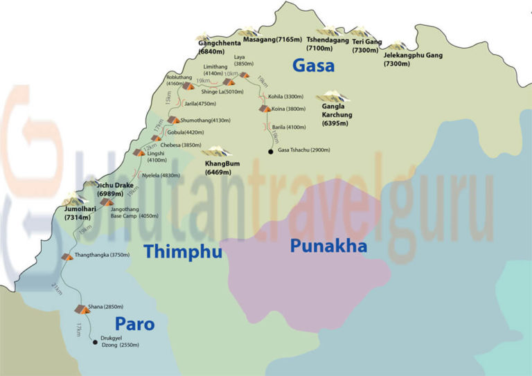
Route Map
Payment
conditions
COST INCLUDES
- Sustainable Development Fee (SDF)
- Accommodation
- All meals
- Transport
- All internal taxes & charges
- Licensed Bhutanese Tour Guide
- Equipment & haulage for trekking tours
COST EXCLUDES
- Flight tickets
- Insurance
- Drinks and Beverages
- Tips
- Internet and Phone bills
- Other bills of personal nature
INSURANCE
Package does not include insurance of any kinds, and that you are required to obtain separate coverage from your home country before your trip begins.
Interested in this trip?
Related tours
Copyright © Bhutan Travel Guru - All Rights Reserved.